
Key Takeaways
- The Whitefish Bay Scenic Byway is a 27-mile route (one way) from Brimley to Paradise along Lake Superior in Michigan’s Hiawatha National Forest, featuring stops like Point Iroquois Lighthouse, Mission Hill Overlook, and Naomikong Overlook.
- Best visited in autumn or summer; allow 2-4 hours due to scenic pull-offs, with practical tips including fueling up beforehand, expecting spotty cell service, and watching for moose/deer.
- Highlights hidden gems like “Singing Sands” beach and Waiska River birdwatching, offering a serene escape from I-75 with natural beauty and maritime history.
For the weary I-75 traveler, the world often narrows to a ribbon of asphalt and the blur of green exit signs. But just beyond the towering span of the Mackinac Bridge, where the air grows sharp with the scent of cedar and the Great Lakes begin to assert their dominance, a different kind of journey awaits. To turn off the interstate and onto the Whitefish Bay Scenic Byway is to step out of time itself.
This is not merely a shortcut or a scenic detour; it is a transition into a landscape where the water of Lake Superior-the “Gitche Gumee” of legend-dictates the pace of life. Here, the atmosphere is heavy with the ghosts of ancient shipwrecks and the quiet resilience of the Hiawatha National Forest. The Whitefish Bay Scenic Byway stretches along the shoreline like a silver thread, weaving between towering pines and the restless, iron-tinted waves of the bay. It is a route that demands you roll down your windows, silence the radio, and listen to the symphony of the North: the rhythmic lap of cold water against ancient stones and the hushed sigh of the wind through the balsam firs.
Fast Facts for the Road
Before you leave the modern world behind, here are the essential details for the Whitefish Bay Scenic Byway:
- Total Mileage: Approximately 27 miles (one way) from Brimley to the junction near Paradise.
- Recommended Travel Time: 2 to 4 hours. While the mileage is short, the allure of the overlooks and shorelines will entice you to linger.
- Best Time of Year to Visit:
- Autumn (Late September to Mid-October): For a kaleidoscopic display of maples and birches against the deep indigo of the bay.
- Summer (July to August): To catch the rare warmth of the Superior breeze and the vibrant blooms of wildflowers.
- Winter: Only for the brave and well-equipped; the road becomes a silent, snow-muffled cathedral.
The Route & Main Stops: A Geographic Walkthrough
The journey begins just west of Sault Ste. Marie. As you exit I-75 and head toward the village of Brimley, the industrial grit of the locks fades, replaced by the sprawling expanse of Whitefish Bay. The road, hugging the shoreline, begins its winding dance through the Hiawatha National Forest.
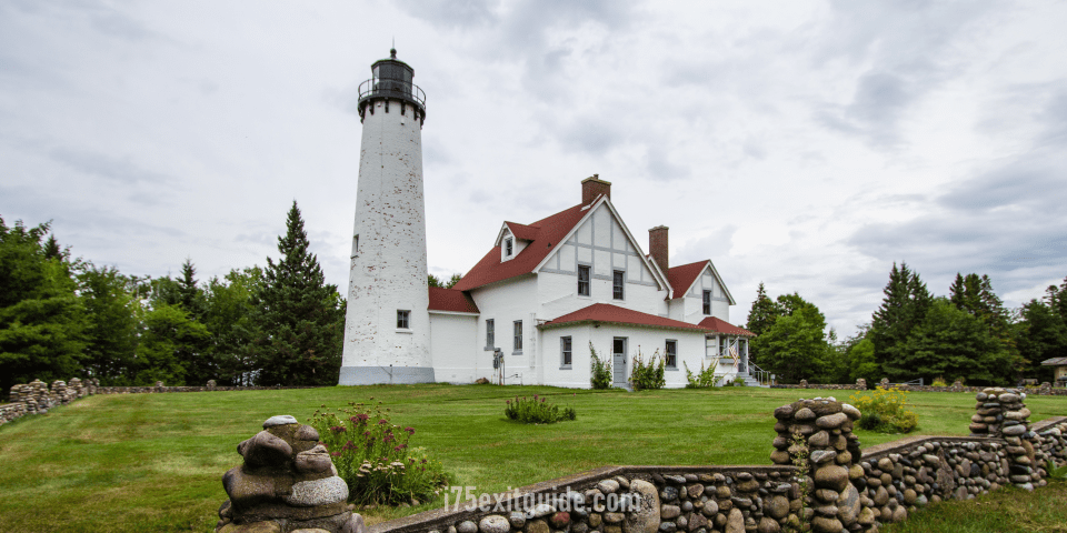
Point Iroquois Lighthouse: The Silent Sentinel
Your first major encounter with history sits at the eastern gateway of the Whitefish Bay Scenic Byway. Point Iroquois Lighthouse, with its stark white tower and red-roofed keeper’s quarters, has stood watch over the entrance to the St. Marys River since 1855.
Walking the grounds, you can feel the weight of the maritime past. The beach here is a treasure trove of “Superior jewels”-smooth, water-worn stones of jasper, agate, and basalt. Stand on the shoreline and look north; you are watching the massive freighters, the “iron boats,” as they navigate the treacherous passage into the bay. The smell here is distinct: a mixture of cold, fresh water and the faint, earthy scent of damp driftwood. It is a place of profound stillness, where the only sound is the crunch of pebbles beneath your boots.
Mission Hill Overlook: The World from Above
A few miles further west, the road climbs sharply. Follow the signs for Mission Hill, and you will be rewarded with perhaps the most breathtaking vista in the Upper Peninsula. From this high ridge, the forest floor drops away, revealing a panoramic tapestry of the bay.
On a clear day, the water shifts through a dozen shades of blue-from a pale turquoise near the sandbars to a bruised, deep navy where the depths plummet. You can see the Canadian hills rising like blue shadows on the distant horizon and the winding path of the road you just traveled. It is a place for reflection, where the sheer scale of the Great Lakes becomes visceral. The wind at the overlook often carries the scent of sun-warmed pine needles, a sharp, resinous perfume that defines the Northwoods.
Monocle Lake: The Mirror in the Woods
Tucked just inland from the bay’s edge is Monocle Lake. If Whitefish Bay is the roaring heart of the region, Monocle Lake is its quiet soul. This inland gem is often perfectly still, reflecting the surrounding hardwoods with such clarity that it’s hard to tell where the sky ends and the water begins.
A gentle hiking trail circles the lake, leading you through stands of ancient hemlock. The boardwalks creak softly underfoot, and the air is cool and damp, smelling of moss and decaying leaves-the rich, fertile scent of a forest that has remained undisturbed for generations. It is the perfect spot to pause for a picnic, away from the rhythmic crashing of the Great Lake’s surf.
Pendills Creek: The Lifeblood of the Bay
As the byway continues west, you will cross Pendills Creek. This is a vital artery for the region’s ecology, home to a National Fish Hatchery that helps sustain the lake trout populations of Lake Superior.
The creek itself is a study in clarity. The water is tea-colored from the tannins of the cedar swamps but crystal clear, revealing every pebble on its bed. There is a small bridge here where you can watch the water rush toward its union with the bay. The sound is a constant, melodic babble that contrasts with the heavy, percussive thud of the lake’s waves nearby.
Naomikong Overlook: The Edge of the Wilderness
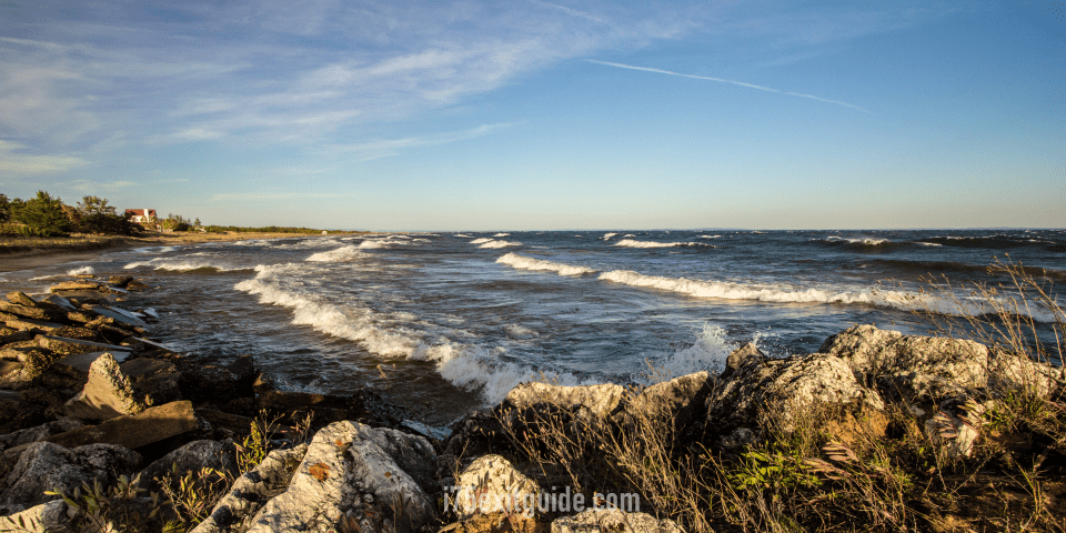
Toward the western end of the Whitefish Bay Scenic Byway lies Naomikong. This area feels wilder, more remote. The shoreline here is rugged, defined by sweeping curves of sand and weathered timber. The Naomikong Overlook provides a stunning vantage point over the “Big Sea Water.”
Here, the power of Lake Superior is on full display. Even on a calm day, the swells possess a heavy, rhythmic energy. In the autumn, the waves here can become giants, throwing spray high into the air. The boardwalks lead you down toward the beach, through thickets of thimbleberry and fern. It is a place that feels ancient, as if you have reached the very edge of the inhabited world.
Hidden Gems: The Local Secrets
While the main stops are well-marked, the true magic of the Whitefish Bay Scenic Byway often lies in the spaces between.
The “Singing Sands” of Emerson
Near the western terminus of the Whitefish Bay Scenic Byway, near the mouth of the Tahquamenon River, lies the ghost town of Emerson. While little remains of the old lumbering village, the beaches here are legendary among locals. The sand is of a specific grain and mineral composition that, when walked upon in a certain way, produces a faint, melodic “squeak” or “singing” sound. It is a haunting, beautiful phenomenon that requires a quiet spirit and a slow pace to discover.
The Waiska River Mouth
At the very start of the Whitefish Bay Scenic Byway near Brimley, the Waiska River empties into the bay. Most travelers speed past, but locals know this as a sanctuary for birdlife. In the early morning mist, you can see Great Blue Herons standing like statues in the shallows and hear the eerie, prehistoric cry of the Sandhill Crane. It is a liminal space-neither fully river nor fully lake-where the water is dark and the silence is absolute.
Practical Tips for the Northwoods Traveler
Driving the Whitefish Bay Scenic Byway is an exercise in slowing down, but it requires a bit of preparation to ensure the journey remains peaceful.
- Fuel and Supplies: Do not wait until your tank is low. Fill up in Sault Ste. Marie or St. Ignace before heading out. Once you are on the byway, gas stations are non-existent until you reach the small community of Paradise.
- Cellular Silence: Prepare for “digital detoxification.” Cell service along the byway is spotty at best and non-existent at worst. Download your maps for offline use, or better yet, carry a physical map. Embrace the disconnection.
- Road Conditions: The Curley Lewis Memorial Highway is a well-paved, two-lane road, but it is winding. Be mindful of “frost heaves” in the early spring. During the winter, the road can be slick with “black ice” blown off the lake, and heavy snow can make visibility difficult.
- Wildlife Awareness: This is the heart of moose and deer country. These animals are most active at dawn and dusk. Keep your speed moderate and your eyes scanning the shoulders; a collision with a 1,000-pound moose is a sobering way to end a road trip.
- Vehicle Recommendations: While any standard sedan can handle the byway, a vehicle with decent clearance is helpful if you plan to explore some of the unpaved forest service roads that branch off the main route.
Conclusion: The Lasting Echo of the North
As the Whitefish Bay Scenic Byway draws to a close and merges with the road leading toward the thundering Tahquamenon Falls or the lonely reaches of Whitefish Point, you may find yourself checking your rearview mirror with a sense of longing.
The interstate offers speed, efficiency, and the comfort of the familiar, but the byway offers something far more precious: a reconnection with the elemental forces of nature. It is a route that stays with you long after the red dust of the Upper Peninsula has been washed from your tires. You will remember the way the light hit the water at Mission Hill, the cold shock of the bay against your skin at Point Iroquois, and the profound, humbling silence of the Hiawatha National Forest.
For the I-75 traveler, the Whitefish Bay Scenic Byway is not just a road; it is a reminder that the most beautiful parts of the journey are often found when we choose to wander. It is a place where the Great Lake whispers its secrets to those who are willing to slow down and listen. So, the next time you cross the bridge and feel the pull of the North, turn left. The bay is waiting.
The I-75 Exit Guide is the Internet’s largest and most complete website dedicated to Interstate 75 travelers. Find detailed exit service listings… lodging, camping, food, gas and more for every exit from Michigan to Florida!
On the road? Why not take us with you. The I-75 Exit Guide is mobile-friendly and totally FREE. No App Required.
Traveling another route? Visit our growing family of exit guides: I-4 Exit Guide, I-5 Exit Guide, I-10 Exit Guide, I-75 Exit Guide, I-80 Exit Guide and I-95 Exit Guide. Detailed exit service listings… discount lodging, camping, food, gas and more for every exit along the way!


